Geospatial data is the key to powering the next generation of applications. With growing amounts of location data available through new satellites, sensors and drones, it’s opening up new possibilities for businesses and organizations to provide rich user experiences and more advanced decision making. To make it easy for developers to build geospatial applications, MariaDB is making an acquisition that adds advanced modern geospatial capabilities that are API driven.
What is geospatial data?
Geospatial data is simply data that is connected to a particular location on the surface of the earth. This may be a city, a zip code, an address or a set of coordinates. It has been estimated that up to 80% of all data is geospatial or has a geospatial component.
Vector vs raster data
Geospatial data comes in two main forms, called “vector” and “raster”. Vector data is described using coordinates, like latitude and longitude. It is used to represent things like rivers, roads and railways in the real world. Raster data covers things like satellite images and elevation maps, where a sample or measurement is taken at regular intervals covering a grid. For an elevation map, these would be heights. For satellite images, they may be color values, radar reflectance, an infra-red reading etc. If you’ve used Google Maps to plan a trip, you’re looking at vector data. If you’ve switched it into “satellite view”, you’re looking at raster data.
For example, the following diagram shows two ways of representing the letter A, first as a raster, and then as a vector.
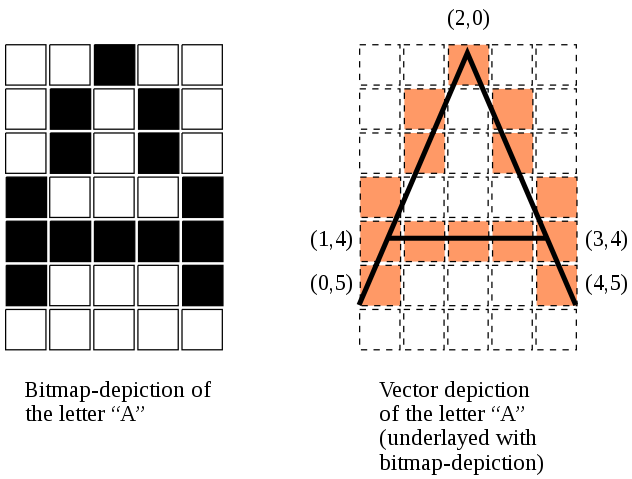
Image credit, Bitmap vs vector, CC BY-SA 3.0
The traditional challenges of geospatial
Geospatial data has always presented unique challenges for application developers. The nature of the data meant that typical data sets were extremely large and hard to manage. A lack of standards in data representation and APIs led to a proliferation of conflicting models and development platforms. Most database vendors implemented support for some geospatial data and operations, but those designs lacked the standardization of something like SQL and led to vendor lock-in, proprietary architectures and fragmentation of the developer communities.
A better way forward with open standards
These forces drove the development of Open Standards for the storage, access and management of geospatial data. The Open Geospatial Consortium (OGC) was the driving force behind these standards. Hundreds of companies and researchers worked together to define conventions and APIs covering all aspects of geospatial data management. These standards provide true interoperability between vendor solutions.
Building geospatial applications today
Geospatial was no exception when application development shifted to web centric models. Earlier versions of the OGC APIs have given way to modern, developer-friendly REST designs and cloud-native data storage formats that allow application developers to implement “just enough geospatial” to accomplish their goals, without needing a deep knowledge of geospatial. There are many freely available JavaScript toolkits that can integrate these services with just a few lines of code.
MariaDB’s vision for geospatial
With the CubeWerx acquisition, MariaDB acquired a geospatial team that has been deeply involved in bringing about the modern geospatial programming paradigm, as well as a massively scalable, cloud-native web services platform built around the MariaDB database that supports all versions of the OGC APIs. MariaDB will leapfrog the competition on geospatial by embracing the new realities of the cloud, and modern REST APIs for application development.